Michigan Two Peninsulas: Why This Is the Only US State Made of Two Separate Land Masses
The phrase Michigan two peninsulas sounds simple enough, but once you really sit with it, it becomes one of the most fascinating quirks in American geography. Michigan is the only state in the entire country made up of two distinct peninsulas — the Lower Peninsula (LP) and the Upper Peninsula (UP) — separated by water and connected by one of the greatest engineering feats of the 20th century. I still find myself stopping mid-conversation to explain this to out-of-state friends who assume Michigan is just one chunk of land shaped like a mitten.
It is so much more than that. From the sweeping dunes of the LP to the ancient waterfalls and iron-red cliffs of the UP, Michigan geography is unlike anything else in the US, and the cultural divide between the people who live on each peninsula is just as rich and layered as the land itself. Whether you are planning your first visit or your fiftieth, understanding the two-peninsula story will completely change how you experience this state.
Michigan Geography 101: Two Peninsulas, One State
Michigan geography starts with a single defining fact: no other US state is split into two non-contiguous land masses the way Michigan is. The Lower Peninsula — shaped famously like a right-hand mitten — is bordered by Lake Michigan to the west, Lake Huron to the east, and Lake Erie to the southeast. The Upper Peninsula stretches westward from the St. Marys River along the shores of Lake Superior, Lake Michigan, and Lake Huron. Together, the two peninsulas give Michigan the longest freshwater coastline of any state, more than 3,200 miles of it.
How Did Michigan End Up With Two Peninsulas?
The short answer is: a border dispute with Ohio. In 1835, Michigan and Ohio nearly went to war — historians call it the Toledo War — over a strip of land near the Maumee River. Congress ultimately awarded Ohio the Toledo Strip and, as compensation, gave Michigan most of what is now the Upper Peninsula. At the time, many Michigan residents were furious. The UP looked like a frozen wilderness with little obvious value. Of course, that assessment aged terribly. The UP turned out to contain some of the richest copper and iron ore deposits in the world, fueling America’s industrial revolution. Today it is treasured for something entirely different: its raw, almost untouched natural beauty.
The Straits of Mackinac
Between the two peninsulas sits the Straits of Mackinac, a roughly five-mile-wide channel where Lake Michigan and Lake Huron meet. The water here is a shade of blue that I can only describe as somewhere between a glacier lake and a Caribbean cove — impossibly clear, shockingly cold. This strait is the geographic heart of Michigan, and it is where the story of the two peninsulas becomes most dramatic. Standing on the shore of Mackinac Island and looking north toward the UP or south toward the LP, you feel the full weight of Michigan’s split identity.
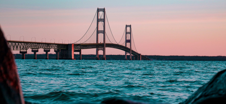
The Mighty Mackinac Bridge: Connecting UP and LP Michigan
For the first 120 years of Michigan statehood, getting between the UP and LP Michigan meant taking a ferry — a journey that could take hours and was weather-dependent in a region known for brutal winters. That changed on November 1, 1957, when the Mackinac Bridge opened to traffic. Stretching 5 miles across the Straits of Mackinac, it was the longest suspension bridge in the Western Hemisphere at the time of its completion, and it remains one of the most spectacular drives in the country. I have crossed it dozens of times and the view never gets old — white-capped water in every direction, the smell of cold lake air rushing through the car window, and the faint hum of the steel grates beneath the tires.
Pro Tip: Every Labor Day, the Mackinac Bridge is closed to vehicle traffic for the annual Bridge Walk, where thousands of people walk the full five miles across. Governor Gretchen Whitmer traditionally walks alongside regular citizens. It is one of the most uniquely Michigan experiences you can have — plan ahead, because parking fills up fast on both ends.
Yoopers vs. Trolls: The Great Cultural Divide
Ask any Michigander about the UP LP Michigan divide and you will get a grin within seconds. The cultural gap between the two peninsulas is real, affectionate, and a little bit absurd — which is exactly why people love it.
Who Are the Yoopers?
Residents of the Upper Peninsula call themselves Yoopers, a phonetic spelling of “U.P.-ers.” Yooper culture is defined by resilience, self-sufficiency, dark humor about weather, and a fierce pride in living somewhere most people could not hack. The Yooper accent — a musical, almost Scandinavian lilt influenced by the Finnish, Swedish, and Cornish immigrants who came to work the mines — is instantly recognizable. Pasties (meat-filled pastry pockets, pronounced PASS-tees, not PASTE-ees, please) are basically the UP’s official food. You will find them at gas stations, bakeries, and church fundraisers alike. The smell of one fresh from the oven, all savory beef and buttery crust, is a full sensory memory for anyone who grew up going to the UP.
Who Are the Trolls?
Lower Peninsula residents are called Trolls by Yoopers — because they live “under the bridge.” Trolls tend to shake their heads at this nickname, which is of course exactly the reaction Yoopers are going for. LP Michigan is home to the state’s major cities, including Detroit and Frankenmuth, as well as the wine regions, the dunes, and the cherry orchards around Traverse City. If Yoopers define themselves by what they endure, Trolls define themselves by what they enjoy — beaches, festivals, breweries, and a more temperate (comparatively) climate.
Fun UP vs. LP Cultural Differences at a Glance
| Category | Upper Peninsula (Yoopers) | Lower Peninsula (Trolls) |
|---|---|---|
| Signature Food | Pasty (meat pie) | Cherry pie / Coney dog |
| Attitude Toward Winter | “It builds character” | “I am moving to Florida” |
| Favorite Weekend Activity | Snowmobiling, ice fishing | Wine trail, beach days |
| Population Density | ~14 people per square mile | ~175 people per square mile |
| Accent | Yooper (Scandinavian-inflected) | Great Lakes flat vowels |
| Relationship With the Bridge | “It brings in the Trolls” | “It is how we get to the UP” |
| Official Nickname for Other Group | Trolls | Yoopers (affectionate) |
Upper Peninsula Highlights You Cannot Miss
The Upper Peninsula covers about 29 percent of Michigan’s total land area but holds less than 3 percent of its population. That math produces something magical: enormous stretches of wilderness with waterfalls, cliff faces, and old-growth forests that feel genuinely remote.
Pictured Rocks National Lakeshore
The crown jewel of the UP, Pictured Rocks stretches 42 miles along Lake Superior. The mineral-streaked sandstone cliffs — banded in rust, copper, white, and green — rise up to 200 feet above water that is so cold and clear you can see the bottom in 20 feet. Kayaking beneath those cliffs, with the sound of waves slapping stone and the smell of pine drifting off the forest above, is one of the most sensory-rich experiences Michigan offers. Combine it with Michigan waterfalls nearby like Miners Falls and Munising Falls for a full UP adventure.
Michigan Camping in the UP
If you want to sleep under more stars than you thought existed, Michigan camping in the UP is hard to beat. Sites along the Lake Superior shoreline at Porcupine Mountains Wilderness State Park or Tahquamenon Falls State Park put you in some of the least light-polluted skies east of the Mississippi. The sound of the lake at night — a low, rhythmic roar when the wind picks up — will rearrange your brain chemistry in the best possible way.
Pro Tip: If tent camping sounds like too much, Michigan glamping options have exploded across the UP in recent years, including yurts with lake views and restored Airstreams near Pictured Rocks. You get the wilderness experience without sacrificing the hot shower.
Lower Peninsula Highlights Worth the Drive
The LP is where most of Michigan’s tourism infrastructure lives, and for good reason. From Lake Michigan beaches that rival anything in the Caribbean (minus the warmth) to world-class Michigan craft beer scenes in Grand Rapids and beyond, the Lower Peninsula has a depth of experiences that rewards repeat visits.
Sleeping Bear Dunes
On the LP’s northwestern shore, Sleeping Bear Dunes offers something you genuinely cannot find elsewhere in the Midwest: massive sand dunes rising 450 feet above Lake Michigan. The climb up is a quad-burning, sand-in-your-shoes, laugh-until-you-can’t-breathe experience. The view from the top — all turquoise water, green islands, and endless sky — makes every step worth it. Nearby, the Michigan lighthouses of the Leelanau Peninsula add a layer of maritime history that ties the whole region together.
Traverse City and the Cherry Country
Traverse City sits at the heart of a region that produces nearly 75 percent of the country’s tart cherries. Every July, the National Cherry Festival transforms the waterfront into a week-long celebration of pie, parades, and live music. The Michigan wine trail that winds through the Old Mission and Leelanau peninsulas has produced some genuinely award-winning Rieslings and Pinot Noirs, and the tasting rooms feel nothing like corporate wine country — they are small, warm, and usually run by the same family that planted the vines.
Holland Michigan and the Tulip Time Tradition
Holland Michigan is one of the Lower Peninsula’s most charming surprises. Dutch heritage runs deep here — deep enough that the city plants more than four million tulip bulbs every year, and the annual Tulip Time Festival draws hundreds of thousands of visitors. Walking the streets when the tulips are in full bloom, surrounded by the sweet, faintly powdery scent of millions of flowers, feels almost theatrical.
UP vs. LP: A Side-by-Side Comparison
For travelers trying to decide where to focus their Michigan road trip, understanding the practical differences between the two peninsulas helps enormously. Visit Pure Michigan for official tourism resources on both peninsulas, including seasonal travel guides and event calendars.
The UP rewards slow travel — dirt roads, roadside waterfalls, towns where the diner closes at 2pm because everyone knows everyone and someone always has somewhere to be. The LP rewards variety — you can beach-hop along Michigan beaches, hunt for Petoskey stones along the northern shore, hike through Michigan state parks, and kayak a river all within a single long weekend. The Michigan hiking scene spans both peninsulas, but the UP trails hit differently — longer, quieter, with real wilderness on both sides of the path.
Frequently Asked Questions
Why does Michigan have two peninsulas?
Michigan ended up with two peninsulas largely because of the Toledo War of 1835, a border dispute with Ohio over the Toledo Strip. Congress resolved the conflict by awarding Ohio the disputed strip and giving Michigan the Upper Peninsula as compensation. What seemed like a consolation prize turned out to contain enormous mineral wealth and some of the most spectacular wilderness in North America.
What are the two peninsulas of Michigan called?
Michigan’s two peninsulas are the Upper Peninsula (UP) and the Lower Peninsula (LP). Residents of the UP are called Yoopers, and residents of the LP are called Trolls by Yoopers — because they live “under” the Mackinac Bridge.
How are the Michigan Upper Lower Peninsula connected?
The Michigan Upper and Lower Peninsulas are connected by the Mackinac Bridge, a five-mile suspension bridge that opened in 1957 and crosses the Straits of Mackinac. Before the bridge, travelers had to rely on ferry service across the straits. Mackinac Island, located in the straits, is accessible only by ferry or small plane year-round.
Is Michigan the only state with two peninsulas?
Yes. Michigan is the only US state composed of two distinct peninsulas separated by water. No other state has a comparable geographic structure, which makes Michigan geography genuinely unique in American cartography.
What is the best way to experience both UP LP Michigan in one trip?
A classic approach is to drive north through the LP, cross the Mackinac Bridge, spend several days in the UP, and loop back. Combining LP stops like Sleeping Bear Dunes and Traverse City with UP highlights like Pictured Rocks and Tahquamenon Falls gives you a full picture of what makes this state so extraordinary. Budget at least 10 days if you want to do both peninsulas any real justice.
What is a pasty and why is it important to UP culture?
A pasty is a hand-held meat and vegetable pie brought to the UP by Cornish miners in the 19th century. It became the fuel of choice for copper and iron ore miners because it stayed warm for hours inside a coat pocket. Today it is the unofficial food of the Upper Peninsula and a source of enormous regional pride. Eating one fresh from a bakery in Marquette or Calumet is a non-negotiable UP experience.
Michigan’s identity as a two-peninsula state is not just a geography trivia answer — it is the foundation of everything that makes this place worth visiting again and again. The Michigan two peninsulas story shapes the culture, the food, the people, and the landscapes in ways that take years of exploring to fully appreciate. Whether you start your adventure with Michigan road trips that weave through both peninsulas, chase waterfalls and copper-streaked cliffs in the Upper Peninsula, paddle the Michigan kayaking routes of the LP, explore Michigan hidden gems off the tourist trail, or bring the whole family along for Michigan with kids adventures, you will find that two peninsulas are always better than one.